Zu Hauptinhalt springenZur Suche springenZu Hauptnavigation springenZu Footer springen
Logo der Fachhochschule Nordwestschweiz
  • DE
  • Startseite

Zehn Hochschulen Ein Ziel

Die FHNW umfasst 10 Hochschulen mit unterschiedlichen Schwerpunkten. Wählen Sie eine Hochschule aus, um deren spezifische Kurse, Studiengänge und Informationen zu sehen.

Angewandte Psychologie

Architektur, Bau und Geomatik

Gestaltung und Kunst

Informatik

Life Sciences

Musik

Pädagogische Hochschule

Soziale Arbeit

Technik und Umwelt

Wirtschaft

  • Studienangebot

    • Alle Studiengänge
    • Bachelor-Studiengänge
    • Master-Studiengänge
    • Info-Anlässe
  • Rund ums Studium

    • Erfahrungsberichte
    • Informationen zum Studium
    • Studienberatung
  • Internationales Studium

    • Informationen zum internationalen Studium
  • Weiterbildungsangebot

    • Alle Weiterbildungen
    • MAS - Master of Advanced Studies
    • DAS - Diploma of Advanced Studies
    • CAS - Certificate of Advanced Studies
    • Kurse / Fachveranstaltungen
    • Info-Anlässe
  • Forschung

    • Forschungsfelder
    • Forschungsprojekte
  • Zusammenarbeit

    • Dienstleistungen
  • Neuigkeiten und Einblicke

    • News und Storys
  • Veranstaltungen

    • Alle Veranstaltungen
    • Info-Anlässe
  • Medienkontakt

    • Medienmitteilungen
  • Über die Hochschule für Architektur, Bau und Geomatik

    • Hochschulleitung
    • Medienkontakt
    • Personenverzeichnis
  • Institute

    • Institut Architektur
    • Institut Bauingenieurwesen
    • Institut Digitales Bauen
    • Institut Geomatik
    • Institut Nachhaltigkeit und Energie am Bau
Logo der Fachhochschule Nordwestschweiz
  • Zur Hochschule
    • Hochschule für Architektur, Bau und Geomatik
    • Studium
    • Weiterbildung
    • Forschung und Dienstleistungen
    • Medienkontakt
  • Social Media
    • LinkedIn
    • Instagram
    • YouTube
    • TikTok
  • Die FHNW
    • Organisation
    • Hochschulen
    • Standorte
    • Bibliothek FHNW
    • Jobs und Karriere
    • Medienkontakte
  • Support
    • IT-Support
    • Inside FHNW
    • Webmail
  • Datenschutz
  • Impressum
  • Accessibility
  • Studienangebot

    • Alle Studiengänge
    • Bachelor-Studiengänge
    • Master-Studiengänge
    • Info-Anlässe
  • Rund ums Studium

    • Erfahrungsberichte
    • Informationen zum Studium
    • Studienberatung
  • Internationales Studium

    • Informationen zum internationalen Studium
  • Weiterbildungsangebot

    • Alle Weiterbildungen
    • MAS - Master of Advanced Studies
    • DAS - Diploma of Advanced Studies
    • CAS - Certificate of Advanced Studies
    • Kurse / Fachveranstaltungen
    • Info-Anlässe
  • Forschung

    • Forschungsfelder
    • Forschungsprojekte
  • Zusammenarbeit

    • Dienstleistungen
  • Neuigkeiten und Einblicke

    • News und Storys
  • Veranstaltungen

    • Alle Veranstaltungen
    • Info-Anlässe
  • Medienkontakt

    • Medienmitteilungen
  • Über die Hochschule für Architektur, Bau und Geomatik

    • Hochschulleitung
    • Medienkontakt
    • Personenverzeichnis
  • Institute

    • Institut Architektur
    • Institut Bauingenieurwesen
    • Institut Digitales Bauen
    • Institut Geomatik
    • Institut Nachhaltigkeit und Energie am Bau

Geben Sie einen Suchbegriff ein und suchen Sie nach Weiterbildungen, Studienangeboten, Veranstaltungen, Dokumenten und anderen Inhalten.

  • Architektur, Bau und Geomatik
  • Forschung und Dienstleistungen
  • Forschung in Architektur, Bau und Geomatik
  • Forschungsprojekte
Forschungsprojekte

FHNW Researchers Test 3D Camera Integration to Improve Survey-ing in Challenging Conditions, Hochschule für Architektur, Bau und Geomatik FHNW

Forschungsprojekt


    FHNW researchers test a new multi-sensor surveying pole that combines GNSS positioning with 3D Time-of-Flight camera technology. This research explores whether adding a 3D depth camera to existing surveying equipment can make field measurements faster, safer, and more accurate.

    hero-teaser.jpg

    Background

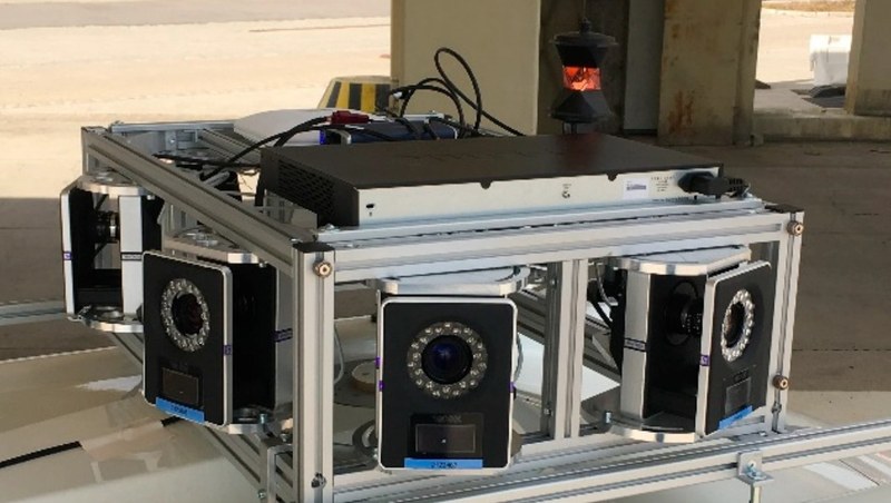
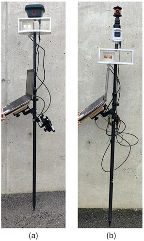
    The team from FHNW's Institute of Geomatics worked with Leica Geosystems to test two setups: one combining a depth camera with a GNSS receiver (GS18 I), and another pairing it with an intelligent surveying pole (AP20) used with total stations. The AP20 combination proved genuine-ly useful, delivering measurements accurately within a few centimeters and working well in diffi-cult conditions like shaded areas or tight spaces where traditional methods struggle. The GNSS setup performed less well and needed more work. What stands out is that the successful AP20 integration could reduce the time surveyors spend in hazardous locations while maintaining pro-fessional-grade accuracy. See Figure 1.

    Figure 1: The functional model of Multi-Sensor-Pole with GS18I(a) and AP20(b)

    Study Link: https://doi.org/10.3390/metrology5040078

    Our Motion Capture System - What is it?

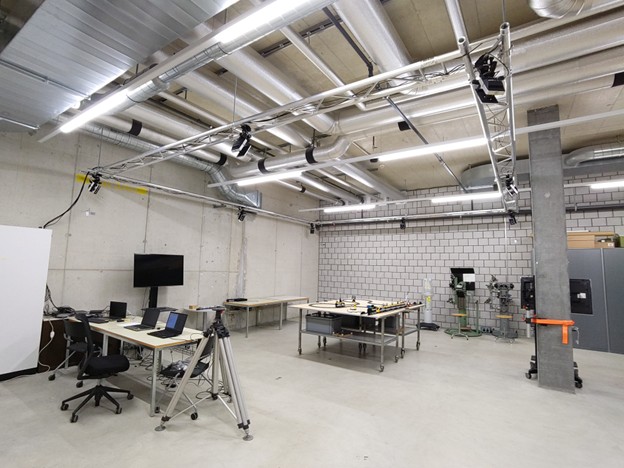
    Our facility features a Vicon motion capture system, which is a high-precision optical tracking technology that uses 8 Vicon Vantage V5 infrared cameras to detect retroreflective markers in 3D space. These cameras are mounted on a specialized ceiling truss to track the movement of objects with sub-millimetre precision. By emitting infrared light and capturing reflections from small markers, the system calculates the exact position and orientation (pose) of any object in real-time. This facility serves as a "gold standard" reference, providing a highly accurate ground truth for testing new sensors, robotic systems, and measurement technologies. See Figure 2.

    Figure 2: Lab Setup

    Engineering a Custom Coordinate System

    To ensure the data is useful for geomatics and engineering applications, the laboratory is integrated into a permanent, high-precision coordinate system. This was achieved by establishing a network of fixed points on the floor and walls, which were surveyed using an industrial-grade Leica AT401 laser tracker. Through a specialized calibration process using a Vicon Active Wand, the motion capture system is "locked" into this physical environment. This allows researchers to measure the movement of robots or vehicles directly within a global laboratory frame, ensuring that digital data perfectly matches the physical world.

    Research Highlight: Autonomous Vehicle Validation

    The facility plays a critical role in Sensor Fusion. In the published study “Highly Accurate Pose Estimation as a Reference for Autonomous Vehicles in Near-Range Scenarios” (Kälin et al., 2022), the FHNW system was used to evaluate localization sensors for autonomous driving. By comparing the data from vehicle-mounted sensors against the ultra-precise Vicon reference, re-searchers can identify even the smallest errors in navigation algorithms. This research is essen-tial for developing the safe and reliable navigation systems required for future self-driving cars in complex, close-range environments (Figure 3).

    Figure 3: Camera Rig.

    This unique setup was developed for highly accurate 6-degree-of-freedom (6DoF) pose estimation with position uncertainty below 5 mm and orientation uncertainty below 0.3°.

    Study Link: https://doi.org/10.3390/rs14010090

    Creative Applications

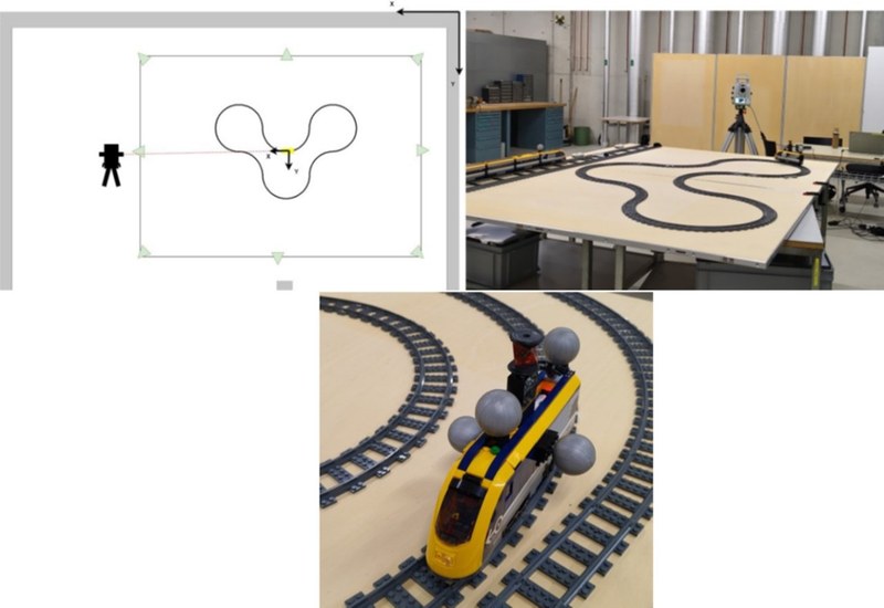
    Beyond automotive research, our facility supports creative and educational experiments. The system's precision has been demonstrated using accessible setups like modified toy trains, mak-ing high-end metrology tangible for students and visitors. An interesting experiment in Figure 4 uses a Lego train with Vicon markers and a track configuration. By attaching both Vicon markers (14 mm passive pearls) and a mini-360-degree prism (Leica GRZ101) to the train, researchers compared the "ground truth" from Vicon to the measurements of the Leica MS60 Multi station. The experiment evaluates how well different computers and operating systems synchronize high-frequency data (Vicon at ~150 Hz vs. Leica MS60 at ~20 Hz).

    Figure 4: Sketch of the experimental set-up in the measurement laboratory (left) and the big curvy train loop (right) with the train at the bottom.

    Kontakt

    David Grimm

    Prof. Dr. David Grimm

    Studiengangsleiter BSc, Geodätische Messtechnik und Geosensorik, Programmleiter CAS Geoinfomation & BIM
    Telefon
    +41 61 228 53 63
    E-Mail
    david.grimm@fhnw.ch

    Dr. Amna Qayyum

    Wiss. Mitarbeiterin
    Telefon
    +41 61 228 52 41
    E-Mail
    amna.qayyum@fhnw.ch

    Hochschule für
    Architektur, Bau und Geomatik Fachhochschule Nordwestschweiz FHNW

    • Zur Hochschule
      • Hochschule für Architektur, Bau und Geomatik
      • Studium
      • Weiterbildung
      • Forschung und Dienstleistungen
      • Medienkontakt
    • Social Media
      • LinkedIn
      • Instagram
      • YouTube
      • TikTok
    • Die FHNW
      • Organisation
      • Hochschulen
      • Standorte
      • Bibliothek FHNW
      • Jobs und Karriere
      • Medienkontakte
    • Support
      • IT-Support
      • Inside FHNW
      • Webmail
    Logo FHNW - 20 Jahre
    Logo Swiss Universities
    Logo European University Association
    © FHNW Fachhochschule Nordwestschweiz
    • Datenschutz
    • Impressum
    • Accessibility
    • DE